


Topographical survey with GPS
The survey with GPS, or Global Positioning System, is a technique widely used in cartography and engineering to determine the position and altitude of points on the Earth’s surface in an accurate manner.
GPS is a satellite navigation system consisting of a network of satellites in orbit around the Earth and GPS receivers on the ground. These receivers pick up the signals emitted by satellites and use the information to calculate the receiver’s exact position in terms of latitude, longitude and altitude.
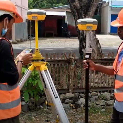
In GPS surveying, GPS receivers are placed at strategic points of interest on the ground. These control points are distributed in such a way as to cover the entire area to be mapped. Each GPS receiver records the signal from several satellites and uses the information to calculate its position in real time.
As data is collected from the GPS receivers, a set of geographic coordinates representing control points on the ground is generated. This data can be used to create accurate and detailed topographic maps, representing the natural and man-made features of a given area, such as elevations, contour lines, rivers, roads, buildings, among others.
GPS surveying offers several advantages over traditional survey methods. Firstly, it is faster and more efficient, as GPS receivers can record data from multiple satellites simultaneously, which speeds up the data collection process.
In addition, GPS provides considerable accuracy, usually within a few centimetres. However, accuracy may vary depending on several factors, such as the availability of satellites and the presence of obstructions on the ground, such as trees or tall buildings.
It is important to note that GPS surveying is a complementary technique to other tools and methods used in the field of surveying. For example, in densely wooded or urban areas, where reception of GPS signals may be difficult, techniques such as total station surveying or terrestrial laser scanning can be used to obtain additional information and ensure the accuracy of the results.
In summary, GPS surveying is a powerful and widely used tool in cartography and engineering. It provides accurate and reliable data on the position and altitude of points on the ground, which is essential for the design and planning of construction projects, the management of natural resources and the creation of detailed topographic maps.
GPS, or Global Positioning System, surveying is used in a variety of applications to determine the position and altitude of points on the Earth’s surface. Depending on the objectives of the survey and the required accuracy, there are different types of GPS surveys used in different contexts. The following are some of the most common types of GPS surveys:
- Static survey: This type of GPS survey is used when high accuracy is required. It consists of placing GPS receivers at fixed control points and recording data continuously over an extended period of time, usually several hours or even days. GPS receivers collect signals from satellites and record the information needed to calculate precise positions. Static surveying is suitable for projects requiring high accuracy, such as earthwork monitoring or the establishment of geodetic reference networks.
- Static Quick Lift: Similar to the static lift, but with a shorter observation time. High-quality GPS receivers are used and information is recorded over several minutes rather than hours or days. Although it offers slightly less accuracy than traditional static surveying, it is faster and still suitable for many surveying and engineering applications.
- Real-time kinematic (RTK) survey: This type of GPS survey is used to obtain real-time, high-accuracy results. It involves the use of a base station and one or more mobile receivers. The base station records GPS signals and sends differential corrections in real time to the mobile receivers. These receivers use the corrections to calculate their positions to centimetre accuracy. Real-time kinematic surveying is widely used in surveying and construction applications, such as road layout and machine positioning.
- Post-processed kinematic survey: In this type of GPS survey, data are collected using mobile receivers and stored in memory for further processing. After data collection, post-processing techniques are used to apply differential corrections to obtain accurate positions. Post-processed kinematic survey is used when high accuracy is required, but real-time results are not necessary.
These are just a few examples of the types of GPS surveys used in different applications. The choice of the appropriate method depends on the requirements of the project, the accuracy needed and the resources available. The use of high quality GPS receivers, correct equipment configuration and proper data processing are key factors in obtaining accurate and reliable GPS survey results.

The use of GPS surveying has revolutionised the way surveying is done and has provided mapping and engineering professionals with an accurate and efficient tool for determining the position and altitude of points on the ground. Topographic GPS is used in a wide variety of applications, from detailed topographic mapping to construction project planning and natural resource management. The following are some of the main uses of topographic GPS:
- Topographic surveying: Topographic GPS is used to collect precise data on the location and elevation of points on the ground. GPS receivers are placed at strategic points and record signals from satellites to calculate the position in real time. This provides precise geographic coordinates that are used to create detailed topographic maps, with information on topography, elevations, contour lines and other relevant geographic features.
- Building and construction control: GPS surveying is used in the planning and control of construction projects. It allows precise control points to be established for the positioning of structures such as buildings, roads or bridges. It is also used for earthworks control, ensuring that excavations, embankments and surface levels are carried out in accordance with project specifications.
- Displacement monitoring: Topographic GPS is used to monitor displacements and ground movements in geotechnically sensitive areas, such as mountain slopes, dams or landslide-prone areas. GPS receivers are placed at control points and regularly recorded to detect any changes in position that may indicate movement or deformation of the terrain.
- Natural resource management: Topographic GPS is used in natural resource management, such as mapping and monitoring of forest areas, delineation of protected area boundaries and identification of water bodies. It is also used for natural resource inventories, such as the location of trees, the delimitation of agricultural areas or the assessment of vegetation cover.
- Navigation and positioning in the field: Portable GPS receivers are used for navigation and positioning in the field. Field professionals, such as surveyors or engineers, use GPS to determine their exact location as they move through the terrain. This allows them to accurately locate and record points of interest during fieldwork.
In short, the use of GPS surveying has transformed the way surveying is carried out and has significantly improved the accuracy and efficiency of mapping and engineering professionals. It provides accurate and reliable geospatial information for use in a wide range of applications, from detailed topographic mapping to construction monitoring and natural resource management.

The price of a topographic GPS can vary significantly depending on several factors, such as brand, model, features and the specific functionalities it offers. It is important to keep in mind that high quality, high precision equipment tends to cost more than lower end or general purpose equipment. The following are some aspects to consider in relation to the price of topographic GPS:
- Make and model: Well-known and established brands in the industry tend to offer higher quality and more reliable equipment, but often also come with a higher price tag. Newer, more technologically advanced models also tend to have a higher price tag than older or more basic models.
- Accuracy and technical characteristics: High-precision topographic GPS, capable of providing centimetre or sub-centimetre results, tend to cost more than standard precision equipment, which provides results in the range of a few metres. Furthermore, additional technical features, such as the ability to receive signals from complementary satellite systems (such as GLONASS or Galileo) or the inclusion of special functions (such as Bluetooth communication or Wi-Fi connectivity), may influence the price of the device.
- Accessories and software: When considering the price of a topographic GPS, it is important to consider whether additional accessories are included, such as external antennas, tripods, extra batteries, carrying cases or other complementary items. In addition, some manufacturers may offer specialised software for processing and managing the collected data, which may influence the overall cost of the system.
- Support and warranty: Manufacturers and suppliers that provide good technical support, training and after-sales assistance usually reflect these services in the price of the GPS surveyor. It is also important to consider the length and conditions of the warranty offered, as this can affect the cost and the user’s peace of mind.
It is essential to conduct thorough research and compare different GPS surveying options before making a purchase decision. It is advisable to consult with industry experts or professionals for recommendations on reliable equipment suitable for the specific needs of the project.


The history of topographic GPS goes back to the origins of the Global Positioning System (GPS) itself. GPS is a satellite navigation system that was developed by the US Department of Defense in the 1970s for military purposes. However, over time, GPS has become an invaluable tool for civilian applications, including surveying.
In its early days, topographic GPS was not as accessible or widely used as it is today. GPS receivers were bulky, expensive and required a specialised level of technical knowledge to operate. In addition, the availability of GPS signals and the accuracy of the data were not as reliable as they are today.
As technology advanced, GPS receivers became more compact, accurate and affordable. This opened up new opportunities for its application in the field of surveying. In the mid-1990s, the first GPS receivers specifically designed for surveying applications became commercially available. These receivers offered increased accuracy and additional functionalities, such as the ability to record data continuously and the capability of connectivity with other devices.
Over time, technological advances allowed the integration of other satellite signals, such as GLONASS (Russian system) and Galileo (European system), which further improved the accuracy and availability of topographic GPS worldwide.
In parallel to advances in GPS technology, there were also significant developments in data processing and visualisation software. Geographic information systems (GIS) and specialised surveying software became more sophisticated, allowing more detailed analysis and interpretation of data collected with topographic GPS receivers.
Today, GPS surveying has become a standard tool in the surveying and mapping industry. GPS receivers are compact, accurate and easy to use, which has led to widespread adoption in surveying projects of all types. The ability to obtain accurate, geo-referenced data in real time has transformed the way surveys are conducted and has improved the efficiency and accuracy of the results.
In short, the history of GPS surveying is an evolution from the first bulky and expensive receivers to the compact and affordable high-precision devices we use today. Technological advances and the growing demand for surveying applications have driven the development and continuous improvement of GPS surveying, making it an essential tool in the field of surveying and mapping.

The accuracy of GPS surveying is a critical factor in surveying and topographic work, as it determines the reliability and quality of the results obtained. The accuracy of topographic GPS refers to the ability of the system to accurately determine the position of a point on the Earth’s surface. The following are some important aspects related to the accuracy of GPS surveying:
- Absolute accuracy: The absolute accuracy of topographic GPS refers to the difference between the position measured by the GPS receiver and the actual position of the point on the ground. It is measured in terms of horizontal error (in the east-west direction) and vertical error (in the altitude direction). Absolute accuracy may vary depending on several factors, such as atmospheric conditions, satellite geometry and the quality of the GPS receiver.
- Relative accuracy: In addition to absolute accuracy, the relative accuracy of GPS surveying is essential for establishing the precise position of points in relation to other reference points. Relative accuracy refers to the accuracy of relative measurements between several points within the same survey. This allows the creation of geodetic networks and the determination of distances and angles between points.
- Factors affecting accuracy: The accuracy of topographic GPS can be affected by several factors, such as satellite geometry (number of visible satellites and their distribution in the sky), atmospheric conditions (e.g. the presence of dense clouds or solar storms) and obstructions in the environment (such as trees, buildings or mountains) that can block or reflect GPS signals.
- Methods to improve accuracy: To improve the accuracy of topographic GPS, techniques such as the use of high quality and accurate GPS receivers, the application of differential corrections (using nearby base stations or real-time correction services), post-processing of the collected data and the use of adjustment and quality control techniques are used.
It is important to note that the accuracy of topographic GPS can vary depending on the quality of the receiver used and the processing techniques applied. In general, high quality and accurate GPS receivers, combined with appropriate processing and quality control techniques, can provide results with an accuracy ranging from a few centimetres to fractions of centimetres.
In summary, the accuracy of GPS surveying is a critical aspect of survey and topographic work. The absolute and relative accuracy of the system can be affected by various factors, and techniques and methods are used to improve it. The choice of a quality GPS receiver and the proper application of processing and quality control techniques are essential for accurate and reliable survey results.

The land surveying is a fundamental process in engineering, architecture and cartography that consists of collecting accurate data on the configuration and physical characteristics of a given area. This survey is carried out using different techniques and tools, and its main objective is to create a detailed and accurate map of the terrain. The following are the main steps involved in a topographic terrain survey:
- Planning: Before the survey begins, thorough planning is carried out. This involves defining the objectives of the survey, determining the scale and accuracy required, establishing the areas of interest and considering the resources available. The availability of existing data, such as previous maps, satellite images or historical information about the area, is also investigated.
- Data collection: In this stage, field data are collected using various techniques and equipment. The most commonly used method is the total station survey, which consists of measuring distances, angles and elevations using optical and electronic instruments. Topographic GPS receivers are also used to obtain precise coordinates of strategic control points. In addition, other tools, such as drones equipped with mapping sensors, can be used to capture aerial imagery and three-dimensional terrain data.
- Data processing and analysis: Once the data has been collected, data processing and analysis is carried out. This involves the use of specialised software that allows the adjustment and correction of data, the generation of digital terrain models, the creation of contour lines and the visualisation of the results in the form of maps or plans. Quality control techniques are applied to verify the accuracy of the data and to correct any errors or discrepancies.
- Generation of final products: With the processed and analysed data, the final products of the topographic survey are generated. These may include detailed topographic maps, elevation plans, digital terrain models, cross-sectional and longitudinal profiles, among others. These products are indispensable tools in the planning and design of engineering and construction projects, natural resource management and decision-making in various industries.
It is important to note that land surveying requires specialised knowledge and technical skills. Professional surveyors and cartographers are responsible for carrying out these surveys and ensuring the accuracy and reliability of the data collected.
In summary, the topographic survey of a terrain is an essential process for understanding and representing the physical characteristics of the terrain. Through the collection of accurate data and its further processing, results are obtained that enable project planning and design, as well as informed decision-making in various application areas.